|
|
|||||||||||||||||
| Point ID: 336 | Downloads | Plots | Site Data | Code: 05BM014 |
|
|
|||||||||||||||||
| Download | |
|---|---|
| Site Descriptor Information | Site Time Series Data |
| Link to all available data | |
| View: | Time Series | All |
| Units: | mm |
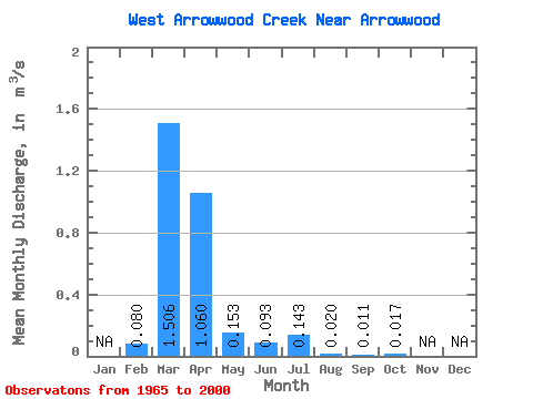
| Statistic | Jan | Feb | Mar | Apr | May | Jun | Jul | Aug | Sep | Oct | Nov | Dec | Annual |
|---|---|---|---|---|---|---|---|---|---|---|---|---|---|
| Mean | 0.08 | 1.51 | 1.06 | 0.15 | 0.09 | 0.14 | 0.02 | 0.01 | 0.02 | ||||
| Standard Deviation | 0.14 | 2.32 | 2.17 | 0.27 | 0.16 | 0.41 | 0.05 | 0.02 | 0.03 | ||||
| Min | 0.00 | 0.01 | 0.00 | 0.00 | 0.00 | 0.00 | 0.00 | 0.00 | 0.00 | ||||
| Max | 0.47 | 10.70 | 10.00 | 1.39 | 0.80 | 2.20 | 0.21 | 0.08 | 0.14 | ||||
| Coefficient of Variation | 1.68 | 1.54 | 2.05 | 1.78 | 1.77 | 2.83 | 2.31 | 1.76 | 1.65 |
 Return to R-Arctic Net Home Page