|
|
|||||||||||||||||
| Point ID: 336 | Downloads | Plots | Site Data | Code: 05BM014 |
|
|
|||||||||||||||||
| Download | |
|---|---|
| Site Descriptor Information | Site Time Series Data |
| Link to all available data | |
| View: | Time Series | All |
| Units: | m3/s |
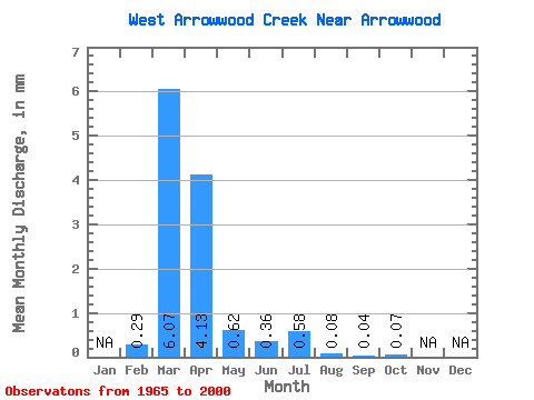
| Statistic | Jan | Feb | Mar | Apr | May | Jun | Jul | Aug | Sep | Oct | Nov | Dec | Annual |
|---|---|---|---|---|---|---|---|---|---|---|---|---|---|
| Mean | 0.25 | 5.21 | 3.54 | 0.53 | 0.31 | 0.49 | 0.07 | 0.04 | 0.06 | ||||
| Standard Deviation | 0.42 | 8.02 | 7.25 | 0.94 | 0.55 | 1.40 | 0.16 | 0.07 | 0.09 | ||||
| Min | 0.00 | 0.04 | 0.01 | 0.00 | 0.00 | 0.00 | 0.00 | 0.00 | 0.00 | ||||
| Max | 1.47 | 36.97 | 33.45 | 4.80 | 2.68 | 7.60 | 0.71 | 0.27 | 0.48 | ||||
| Coefficient of Variation | 1.68 | 1.54 | 2.05 | 1.78 | 1.77 | 2.83 | 2.31 | 1.76 | 1.65 |
 Return to R-Arctic Net Home Page