|
|
|||||||||||||||||
| Point ID: 335 | Downloads | Plots | Site Data | Code: 05BM013 |
|
|
|||||||||||||||||
| Download | |
|---|---|
| Site Descriptor Information | Site Time Series Data |
| Link to all available data | |
| View: | Time Series | All |
| Units: | mm |
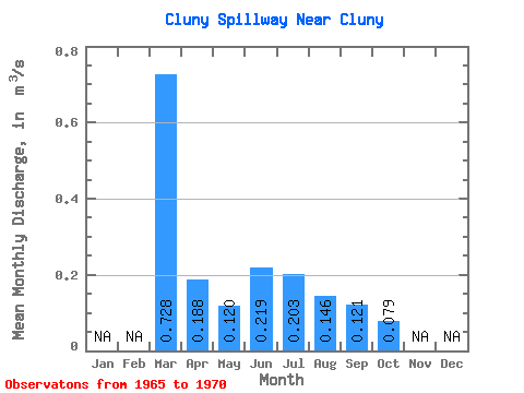
| Statistic | Jan | Feb | Mar | Apr | May | Jun | Jul | Aug | Sep | Oct | Nov | Dec | Annual |
|---|---|---|---|---|---|---|---|---|---|---|---|---|---|
| Mean | 0.73 | 0.19 | 0.12 | 0.22 | 0.20 | 0.15 | 0.12 | 0.08 | |||||
| Standard Deviation | 0.05 | 0.07 | 0.15 | 0.11 | 0.11 | 0.06 | |||||||
| Min | 0.73 | 0.19 | 0.06 | 0.12 | 0.04 | 0.03 | 0.03 | 0.01 | |||||
| Max | 0.73 | 0.19 | 0.17 | 0.29 | 0.49 | 0.33 | 0.32 | 0.15 | |||||
| Coefficient of Variation | 0.38 | 0.32 | 0.76 | 0.74 | 0.88 | 0.70 |
 Return to R-Arctic Net Home Page