|
|
|||||||||||||||||
| Point ID: 335 | Downloads | Plots | Site Data | Code: 05BM013 |
|
|
|||||||||||||||||
| Download | |
|---|---|
| Site Descriptor Information | Site Time Series Data |
| Link to all available data | |
| View: | Time Series | All |
| Units: | m3/s |
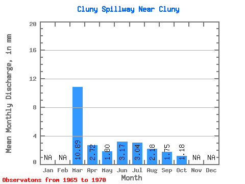
| Statistic | Jan | Feb | Mar | Apr | May | Jun | Jul | Aug | Sep | Oct | Nov | Dec | Annual |
|---|---|---|---|---|---|---|---|---|---|---|---|---|---|
| Mean | 10.89 | 2.72 | 1.79 | 3.17 | 3.04 | 2.18 | 1.76 | 1.18 | |||||
| Standard Deviation | 0.68 | 1.02 | 2.31 | 1.62 | 1.55 | 0.83 | |||||||
| Min | 10.89 | 2.72 | 0.91 | 1.72 | 0.63 | 0.45 | 0.36 | 0.12 | |||||
| Max | 10.89 | 2.72 | 2.47 | 4.17 | 7.39 | 4.98 | 4.65 | 2.27 | |||||
| Coefficient of Variation | 0.38 | 0.32 | 0.76 | 0.74 | 0.88 | 0.70 |
 Return to R-Arctic Net Home Page