|
|
|||||||||||||||||
| Point ID: 326 | Downloads | Plots | Site Data | Code: 05BM004 |
|
|
|||||||||||||||||
| Download | |
|---|---|
| Site Descriptor Information | Site Time Series Data |
| Link to all available data | |
| View: | Time Series | All |
| Units: | mm |
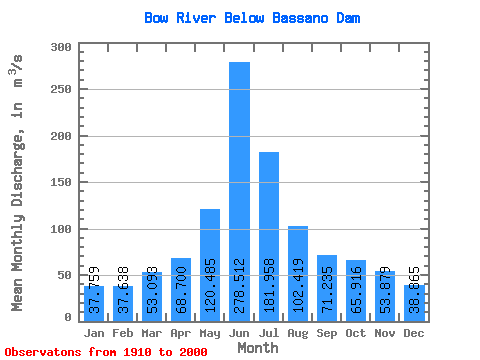
| Statistic | Jan | Feb | Mar | Apr | May | Jun | Jul | Aug | Sep | Oct | Nov | Dec | Annual |
|---|---|---|---|---|---|---|---|---|---|---|---|---|---|
| Mean | 37.76 | 37.64 | 53.09 | 68.70 | 120.48 | 278.51 | 181.96 | 102.42 | 71.23 | 65.92 | 53.88 | 38.87 | 124.60 |
| Standard Deviation | 9.81 | 8.20 | 22.20 | 25.49 | 63.85 | 176.32 | 147.17 | 80.28 | 62.09 | 37.29 | 16.01 | 10.54 | 44.52 |
| Min | 28.20 | 27.20 | 28.50 | 7.99 | 4.63 | 17.80 | 4.64 | 7.73 | 6.95 | 7.09 | 34.70 | 25.30 | 81.12 |
| Max | 68.40 | 52.00 | 119.00 | 131.00 | 273.00 | 851.00 | 772.00 | 352.00 | 292.00 | 188.00 | 84.70 | 63.70 | 229.36 |
| Coefficient of Variation | 0.26 | 0.22 | 0.42 | 0.37 | 0.53 | 0.63 | 0.81 | 0.78 | 0.87 | 0.57 | 0.30 | 0.27 | 0.36 |
 Return to R-Arctic Net Home Page