|
|
|||||||||||||||||
| Point ID: 326 | Downloads | Plots | Site Data | Code: 05BM004 |
|
|
|||||||||||||||||
| Download | |
|---|---|
| Site Descriptor Information | Site Time Series Data |
| Link to all available data | |
| View: | Time Series | All |
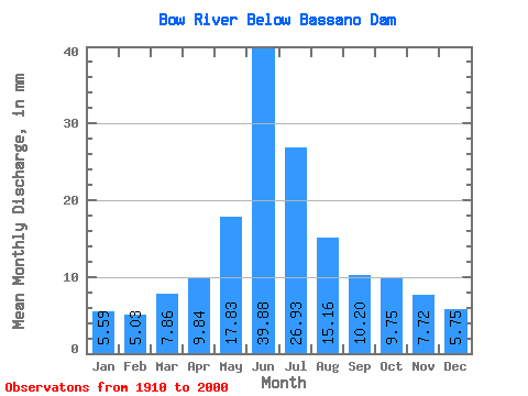
| Units: | m3/s |
| Statistic | Jan | Feb | Mar | Apr | May | Jun | Jul | Aug | Sep | Oct | Nov | Dec | Annual |
|---|---|---|---|---|---|---|---|---|---|---|---|---|---|
| Mean | 4.98 | 4.52 | 7.00 | 8.77 | 15.89 | 35.56 | 24.00 | 13.51 | 9.10 | 8.70 | 6.88 | 5.13 | 193.71 |
| Standard Deviation | 1.29 | 0.99 | 2.93 | 3.25 | 8.42 | 22.51 | 19.41 | 10.59 | 7.93 | 4.92 | 2.04 | 1.39 | 69.21 |
| Min | 3.72 | 3.27 | 3.76 | 1.02 | 0.61 | 2.27 | 0.61 | 1.02 | 0.89 | 0.94 | 4.43 | 3.34 | 126.12 |
| Max | 9.02 | 6.25 | 15.70 | 16.73 | 36.01 | 108.66 | 101.84 | 46.44 | 37.28 | 24.80 | 10.81 | 8.40 | 356.58 |
| Coefficient of Variation | 0.26 | 0.22 | 0.42 | 0.37 | 0.53 | 0.63 | 0.81 | 0.78 | 0.87 | 0.57 | 0.30 | 0.27 | 0.36 |
 Return to R-Arctic Net Home Page