|
|
|||||||||||||||||
| Point ID: 3117 | Downloads | Plots | Site Data | Code: 05UH001 |
|
|
|||||||||||||||||
| Download | |
|---|---|
| Site Descriptor Information | Site Time Series Data |
| Link to all available data | |
| View: | Time Series | All |
| Units: | mm |
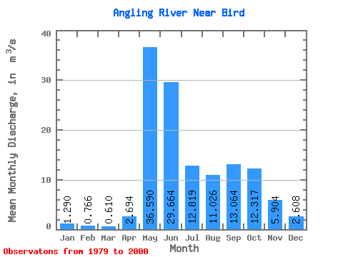
| Statistic | Jan | Feb | Mar | Apr | May | Jun | Jul | Aug | Sep | Oct | Nov | Dec | Annual |
|---|---|---|---|---|---|---|---|---|---|---|---|---|---|
| Mean | 1.29 | 0.77 | 0.61 | 2.69 | 36.59 | 29.66 | 12.82 | 11.03 | 13.06 | 12.32 | 5.90 | 2.61 | 11.81 |
| Standard Deviation | 0.76 | 0.45 | 0.36 | 5.05 | 20.84 | 24.51 | 9.70 | 10.21 | 12.48 | 13.18 | 4.40 | 1.47 | 4.10 |
| Min | 0.26 | 0.19 | 0.09 | 0.29 | 3.55 | 3.39 | 3.42 | 0.56 | 1.43 | 2.75 | 1.20 | 0.33 | 6.20 |
| Max | 3.14 | 1.99 | 1.38 | 17.70 | 79.70 | 123.00 | 32.80 | 30.90 | 45.60 | 64.50 | 18.50 | 5.22 | 20.99 |
| Coefficient of Variation | 0.59 | 0.59 | 0.60 | 1.88 | 0.57 | 0.83 | 0.76 | 0.93 | 0.95 | 1.07 | 0.75 | 0.56 | 0.35 |
 Return to R-Arctic Net Home Page