|
|
|||||||||||||||||
| Point ID: 3117 | Downloads | Plots | Site Data | Code: 05UH001 |
|
|
|||||||||||||||||
| Download | |
|---|---|
| Site Descriptor Information | Site Time Series Data |
| Link to all available data | |
| View: | Time Series | All |
| Units: | m3/s |
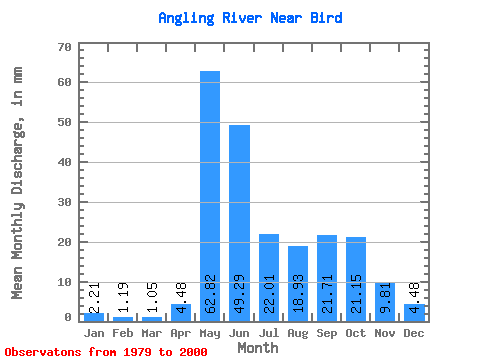
| Statistic | Jan | Feb | Mar | Apr | May | Jun | Jul | Aug | Sep | Oct | Nov | Dec | Annual |
|---|---|---|---|---|---|---|---|---|---|---|---|---|---|
| Mean | 2.21 | 1.20 | 1.05 | 4.48 | 62.81 | 49.29 | 22.01 | 18.93 | 21.71 | 21.14 | 9.81 | 4.48 | 238.96 |
| Standard Deviation | 1.31 | 0.70 | 0.63 | 8.40 | 35.78 | 40.72 | 16.65 | 17.53 | 20.74 | 22.63 | 7.31 | 2.52 | 82.89 |
| Min | 0.44 | 0.30 | 0.15 | 0.48 | 6.09 | 5.63 | 5.87 | 0.96 | 2.38 | 4.72 | 1.99 | 0.57 | 125.52 |
| Max | 5.39 | 3.11 | 2.37 | 29.41 | 136.82 | 204.37 | 56.31 | 53.05 | 75.77 | 110.72 | 30.74 | 8.96 | 424.73 |
| Coefficient of Variation | 0.59 | 0.59 | 0.60 | 1.88 | 0.57 | 0.83 | 0.76 | 0.93 | 0.95 | 1.07 | 0.75 | 0.56 | 0.35 |
 Return to R-Arctic Net Home Page