|
|
|||||||||||||||||
| Point ID: 310 | Downloads | Plots | Site Data | Code: 05BL013 |
|
|
|||||||||||||||||
| Download | |
|---|---|
| Site Descriptor Information | Site Time Series Data |
| Link to all available data | |
| View: | Time Series | All |
| Units: | mm |
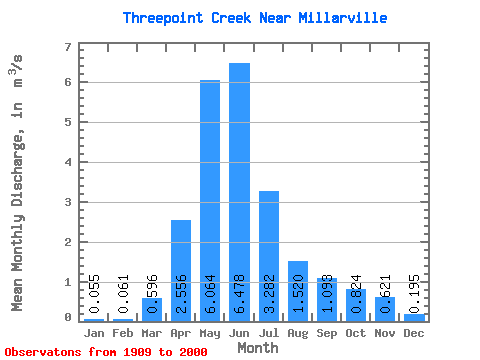
| Statistic | Jan | Feb | Mar | Apr | May | Jun | Jul | Aug | Sep | Oct | Nov | Dec | Annual |
|---|---|---|---|---|---|---|---|---|---|---|---|---|---|
| Mean | 0.06 | 0.06 | 0.60 | 2.56 | 6.06 | 6.48 | 3.28 | 1.52 | 1.09 | 0.82 | 0.62 | 0.20 | |
| Standard Deviation | 0.69 | 1.79 | 4.46 | 4.87 | 3.86 | 2.05 | 1.75 | 1.08 | |||||
| Min | 0.06 | 0.06 | 0.00 | 0.32 | 0.53 | 0.36 | 0.09 | 0.05 | 0.03 | 0.05 | 0.62 | 0.20 | |
| Max | 0.06 | 0.06 | 2.28 | 7.55 | 19.50 | 18.90 | 13.20 | 11.30 | 9.67 | 4.59 | 0.62 | 0.20 | |
| Coefficient of Variation | 1.15 | 0.70 | 0.74 | 0.75 | 1.18 | 1.35 | 1.60 | 1.32 |
 Return to R-Arctic Net Home Page