|
|
|||||||||||||||||
| Point ID: 310 | Downloads | Plots | Site Data | Code: 05BL013 |
|
|
|||||||||||||||||
| Download | |
|---|---|
| Site Descriptor Information | Site Time Series Data |
| Link to all available data | |
| View: | Time Series | All |
| Units: | m3/s |
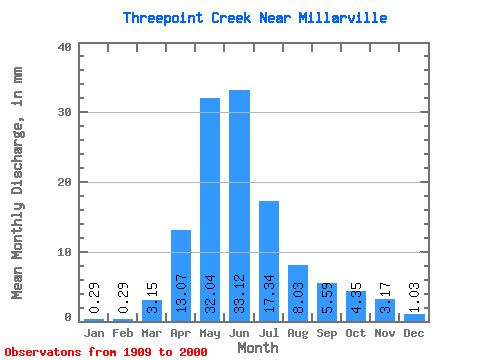
| Statistic | Jan | Feb | Mar | Apr | May | Jun | Jul | Aug | Sep | Oct | Nov | Dec | Annual |
|---|---|---|---|---|---|---|---|---|---|---|---|---|---|
| Mean | 0.29 | 0.29 | 3.15 | 13.07 | 32.03 | 33.12 | 17.34 | 8.03 | 5.59 | 4.35 | 3.17 | 1.03 | |
| Standard Deviation | 3.63 | 9.13 | 23.57 | 24.90 | 20.39 | 10.85 | 8.94 | 5.73 | |||||
| Min | 0.29 | 0.29 | 0.00 | 1.66 | 2.81 | 1.84 | 0.49 | 0.24 | 0.15 | 0.25 | 3.17 | 1.03 | |
| Max | 0.29 | 0.29 | 12.04 | 38.60 | 103.00 | 96.62 | 69.72 | 59.69 | 49.44 | 24.25 | 3.17 | 1.03 | |
| Coefficient of Variation | 1.15 | 0.70 | 0.74 | 0.75 | 1.18 | 1.35 | 1.60 | 1.32 |
 Return to R-Arctic Net Home Page