|
|
|||||||||||||||||
| Point ID: 3098 | Downloads | Plots | Site Data | Code: 05TE002 |
|
|
|||||||||||||||||
| Download | |
|---|---|
| Site Descriptor Information | Site Time Series Data |
| Link to all available data | |
| View: | Time Series | All |
| Units: | mm |
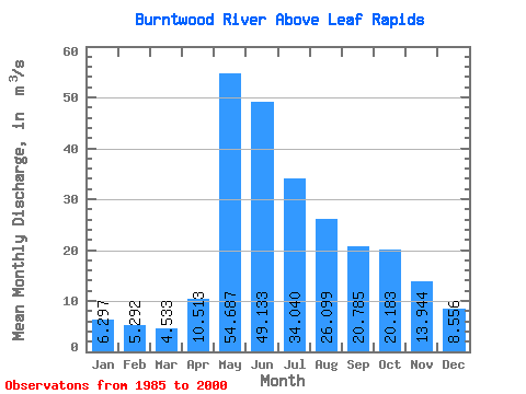
| Statistic | Jan | Feb | Mar | Apr | May | Jun | Jul | Aug | Sep | Oct | Nov | Dec | Annual |
|---|---|---|---|---|---|---|---|---|---|---|---|---|---|
| Mean | 6.30 | 5.29 | 4.53 | 10.51 | 54.69 | 49.13 | 34.04 | 26.10 | 20.79 | 20.18 | 13.94 | 8.56 | 21.06 |
| Standard Deviation | 3.94 | 3.01 | 2.19 | 7.84 | 26.70 | 26.18 | 16.96 | 17.70 | 13.93 | 18.77 | 10.92 | 5.37 | 7.25 |
| Min | 3.21 | 2.89 | 2.23 | 2.82 | 10.90 | 17.40 | 7.90 | 8.66 | 3.75 | 3.90 | 3.88 | 3.51 | 11.57 |
| Max | 18.70 | 14.60 | 11.10 | 29.40 | 104.00 | 103.00 | 68.20 | 68.20 | 53.20 | 84.10 | 50.50 | 26.40 | 35.45 |
| Coefficient of Variation | 0.63 | 0.57 | 0.48 | 0.75 | 0.49 | 0.53 | 0.50 | 0.68 | 0.67 | 0.93 | 0.78 | 0.63 | 0.34 |
 Return to R-Arctic Net Home Page