|
|
|||||||||||||||||
| Point ID: 3098 | Downloads | Plots | Site Data | Code: 05TE002 |
|
|
|||||||||||||||||
| Download | |
|---|---|
| Site Descriptor Information | Site Time Series Data |
| Link to all available data | |
| View: | Time Series | All |
| Units: | m3/s |
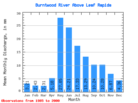
| Statistic | Jan | Feb | Mar | Apr | May | Jun | Jul | Aug | Sep | Oct | Nov | Dec | Annual |
|---|---|---|---|---|---|---|---|---|---|---|---|---|---|
| Mean | 3.21 | 2.46 | 2.31 | 5.18 | 27.84 | 24.21 | 17.33 | 13.29 | 10.24 | 10.28 | 6.87 | 4.36 | 126.38 |
| Standard Deviation | 2.01 | 1.40 | 1.12 | 3.87 | 13.59 | 12.90 | 8.63 | 9.01 | 6.86 | 9.56 | 5.38 | 2.73 | 43.48 |
| Min | 1.63 | 1.34 | 1.14 | 1.39 | 5.55 | 8.57 | 4.02 | 4.41 | 1.85 | 1.99 | 1.91 | 1.79 | 69.42 |
| Max | 9.52 | 6.77 | 5.65 | 14.49 | 52.95 | 50.76 | 34.72 | 34.72 | 26.22 | 42.82 | 24.89 | 13.44 | 212.72 |
| Coefficient of Variation | 0.63 | 0.57 | 0.48 | 0.75 | 0.49 | 0.53 | 0.50 | 0.68 | 0.67 | 0.93 | 0.78 | 0.63 | 0.34 |
 Return to R-Arctic Net Home Page