|
|
|||||||||||||||||
| Point ID: 3089 | Downloads | Plots | Site Data | Code: 05SB002 |
|
|
|||||||||||||||||
| Download | |
|---|---|
| Site Descriptor Information | Site Time Series Data |
| Link to all available data | |
| View: | Time Series | All |
| Units: | mm |
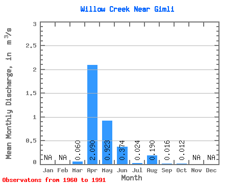
| Statistic | Jan | Feb | Mar | Apr | May | Jun | Jul | Aug | Sep | Oct | Nov | Dec | Annual |
|---|---|---|---|---|---|---|---|---|---|---|---|---|---|
| Mean | 0.06 | 2.09 | 0.92 | 0.37 | 0.02 | 0.19 | 0.02 | 0.01 | |||||
| Standard Deviation | 0.12 | 2.59 | 1.84 | 0.74 | 0.04 | 0.50 | 0.03 | 0.03 | |||||
| Min | 0.00 | 0.01 | 0.00 | 0.00 | 0.00 | 0.00 | 0.00 | 0.00 | |||||
| Max | 0.47 | 11.20 | 8.47 | 3.77 | 0.12 | 1.61 | 0.08 | 0.09 | |||||
| Coefficient of Variation | 2.01 | 1.24 | 1.99 | 1.99 | 1.48 | 2.66 | 1.95 | 2.27 |
 Return to R-Arctic Net Home Page