|
|
|||||||||||||||||
| Point ID: 3089 | Downloads | Plots | Site Data | Code: 05SB002 |
|
|
|||||||||||||||||
| Download | |
|---|---|
| Site Descriptor Information | Site Time Series Data |
| Link to all available data | |
| View: | Time Series | All |
| Units: | m3/s |
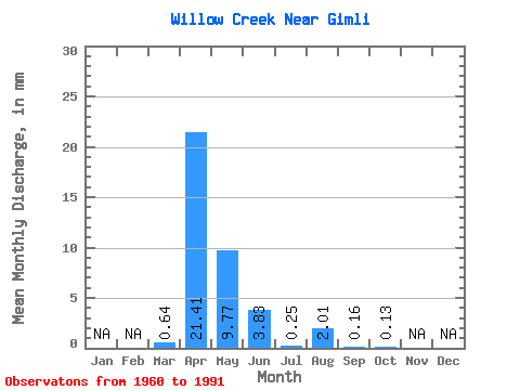
| Statistic | Jan | Feb | Mar | Apr | May | Jun | Jul | Aug | Sep | Oct | Nov | Dec | Annual |
|---|---|---|---|---|---|---|---|---|---|---|---|---|---|
| Mean | 0.64 | 21.42 | 9.77 | 3.83 | 0.25 | 2.01 | 0.16 | 0.13 | |||||
| Standard Deviation | 1.27 | 26.51 | 19.48 | 7.61 | 0.37 | 5.34 | 0.31 | 0.30 | |||||
| Min | 0.00 | 0.10 | 0.00 | 0.00 | 0.00 | 0.00 | 0.00 | 0.00 | |||||
| Max | 5.02 | 114.75 | 89.66 | 38.62 | 1.22 | 17.04 | 0.83 | 0.93 | |||||
| Coefficient of Variation | 2.01 | 1.24 | 1.99 | 1.99 | 1.48 | 2.66 | 1.95 | 2.27 |
 Return to R-Arctic Net Home Page