|
|
|||||||||||||||||
| Point ID: 3077 | Downloads | Plots | Site Data | Code: 05PH006 |
|
|
|||||||||||||||||
| Download | |
|---|---|
| Site Descriptor Information | Site Time Series Data |
| Link to all available data | |
| View: | Time Series | All |
| Units: | mm |
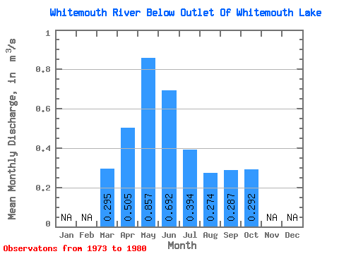
| Statistic | Jan | Feb | Mar | Apr | May | Jun | Jul | Aug | Sep | Oct | Nov | Dec | Annual |
|---|---|---|---|---|---|---|---|---|---|---|---|---|---|
| Mean | 0.29 | 0.51 | 0.86 | 0.69 | 0.39 | 0.27 | 0.29 | 0.29 | |||||
| Standard Deviation | 0.54 | 0.50 | 1.08 | 1.05 | 0.56 | 0.42 | 0.47 | 0.46 | |||||
| Min | 0.00 | 0.06 | 0.07 | 0.01 | 0.00 | 0.01 | 0.01 | 0.00 | |||||
| Max | 1.37 | 1.35 | 3.20 | 3.08 | 1.51 | 1.21 | 1.37 | 1.34 | |||||
| Coefficient of Variation | 1.82 | 0.99 | 1.26 | 1.51 | 1.42 | 1.54 | 1.63 | 1.59 |
 Return to R-Arctic Net Home Page