|
|
|||||||||||||||||
| Point ID: 3077 | Downloads | Plots | Site Data | Code: 05PH006 |
|
|
|||||||||||||||||
| Download | |
|---|---|
| Site Descriptor Information | Site Time Series Data |
| Link to all available data | |
| View: | Time Series | All |
| Units: | m3/s |
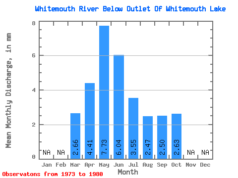
| Statistic | Jan | Feb | Mar | Apr | May | Jun | Jul | Aug | Sep | Oct | Nov | Dec | Annual |
|---|---|---|---|---|---|---|---|---|---|---|---|---|---|
| Mean | 2.66 | 4.41 | 7.73 | 6.04 | 3.55 | 2.47 | 2.50 | 2.63 | |||||
| Standard Deviation | 4.85 | 4.34 | 9.75 | 9.15 | 5.03 | 3.79 | 4.08 | 4.17 | |||||
| Min | 0.00 | 0.52 | 0.68 | 0.11 | 0.04 | 0.10 | 0.11 | 0.02 | |||||
| Max | 12.35 | 11.78 | 28.85 | 26.88 | 13.62 | 10.91 | 11.96 | 12.08 | |||||
| Coefficient of Variation | 1.82 | 0.99 | 1.26 | 1.51 | 1.42 | 1.54 | 1.63 | 1.59 |
 Return to R-Arctic Net Home Page