|
|
|||||||||||||||||
| Point ID: 3074 | Downloads | Plots | Site Data | Code: 05PG002 |
|
|
|||||||||||||||||
| Download | |
|---|---|
| Site Descriptor Information | Site Time Series Data |
| Link to all available data | |
| View: | Time Series | All |
| Units: | mm |
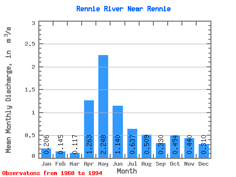
| Statistic | Jan | Feb | Mar | Apr | May | Jun | Jul | Aug | Sep | Oct | Nov | Dec | Annual |
|---|---|---|---|---|---|---|---|---|---|---|---|---|---|
| Mean | 0.21 | 0.14 | 0.12 | 1.26 | 2.25 | 1.14 | 0.64 | 0.51 | 0.33 | 0.49 | 0.44 | 0.31 | 0.57 |
| Standard Deviation | 0.14 | 0.09 | 0.07 | 1.31 | 1.98 | 1.27 | 0.67 | 1.10 | 0.45 | 0.84 | 0.49 | 0.26 | 0.29 |
| Min | 0.00 | 0.00 | 0.00 | 0.01 | 0.00 | 0.01 | 0.01 | 0.01 | 0.00 | 0.00 | 0.00 | 0.00 | 0.02 |
| Max | 0.45 | 0.34 | 0.30 | 4.88 | 7.54 | 4.86 | 2.78 | 5.21 | 2.09 | 4.10 | 1.97 | 0.76 | 1.12 |
| Coefficient of Variation | 0.66 | 0.62 | 0.62 | 1.04 | 0.88 | 1.11 | 1.05 | 2.17 | 1.37 | 1.69 | 1.12 | 0.85 | 0.51 |
 Return to R-Arctic Net Home Page