|
|
|||||||||||||||||
| Point ID: 3074 | Downloads | Plots | Site Data | Code: 05PG002 |
|
|
|||||||||||||||||
| Download | |
|---|---|
| Site Descriptor Information | Site Time Series Data |
| Link to all available data | |
| View: | Time Series | All |
| Units: | m3/s |
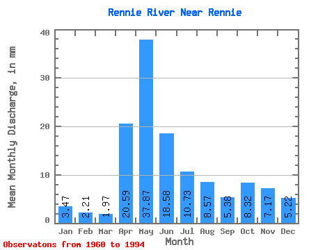
| Statistic | Jan | Feb | Mar | Apr | May | Jun | Jul | Aug | Sep | Oct | Nov | Dec | Annual |
|---|---|---|---|---|---|---|---|---|---|---|---|---|---|
| Mean | 3.47 | 2.23 | 1.97 | 20.59 | 37.87 | 18.59 | 10.72 | 8.57 | 5.37 | 8.32 | 7.17 | 5.22 | 113.13 |
| Standard Deviation | 2.29 | 1.39 | 1.22 | 21.39 | 33.38 | 20.71 | 11.28 | 18.62 | 7.34 | 14.08 | 8.00 | 4.45 | 57.65 |
| Min | 0.02 | 0.00 | 0.00 | 0.08 | 0.05 | 0.15 | 0.14 | 0.10 | 0.07 | 0.02 | 0.00 | 0.02 | 4.81 |
| Max | 7.55 | 5.26 | 5.05 | 79.55 | 126.99 | 79.23 | 46.82 | 87.75 | 34.07 | 69.06 | 32.12 | 12.85 | 222.69 |
| Coefficient of Variation | 0.66 | 0.62 | 0.62 | 1.04 | 0.88 | 1.11 | 1.05 | 2.17 | 1.37 | 1.69 | 1.12 | 0.85 | 0.51 |
 Return to R-Arctic Net Home Page