|
|
|||||||||||||||||
| Point ID: 3041 | Downloads | Plots | Site Data | Code: 05OG008 |
|
|
|||||||||||||||||
| Download | |
|---|---|
| Site Descriptor Information | Site Time Series Data |
| Link to all available data | |
| View: | Time Series | All |
| Units: | mm |
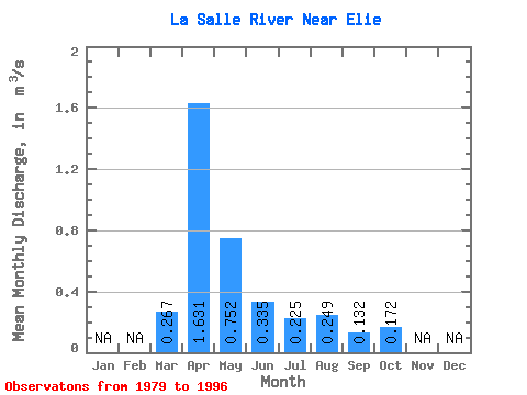
| Statistic | Jan | Feb | Mar | Apr | May | Jun | Jul | Aug | Sep | Oct | Nov | Dec | Annual |
|---|---|---|---|---|---|---|---|---|---|---|---|---|---|
| Mean | 0.27 | 1.63 | 0.75 | 0.34 | 0.23 | 0.25 | 0.13 | 0.17 | |||||
| Standard Deviation | 0.38 | 1.40 | 1.29 | 0.62 | 0.21 | 0.32 | 0.15 | 0.13 | |||||
| Min | 0.00 | 0.04 | 0.01 | 0.00 | 0.00 | 0.00 | 0.00 | 0.00 | |||||
| Max | 1.17 | 4.63 | 3.79 | 2.49 | 0.74 | 1.12 | 0.48 | 0.39 | |||||
| Coefficient of Variation | 1.41 | 0.86 | 1.72 | 1.84 | 0.95 | 1.27 | 1.17 | 0.78 |
 Return to R-Arctic Net Home Page