|
|
|||||||||||||||||
| Point ID: 3041 | Downloads | Plots | Site Data | Code: 05OG008 |
|
|
|||||||||||||||||
| Download | |
|---|---|
| Site Descriptor Information | Site Time Series Data |
| Link to all available data | |
| View: | Time Series | All |
| Units: | m3/s |
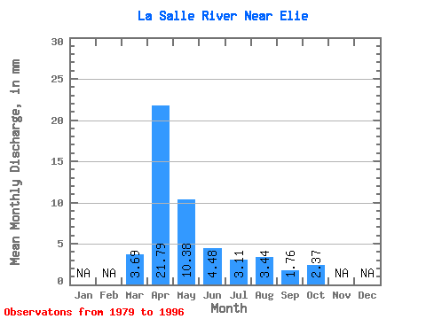
| Statistic | Jan | Feb | Mar | Apr | May | Jun | Jul | Aug | Sep | Oct | Nov | Dec | Annual |
|---|---|---|---|---|---|---|---|---|---|---|---|---|---|
| Mean | 3.68 | 21.79 | 10.38 | 4.48 | 3.10 | 3.43 | 1.76 | 2.38 | |||||
| Standard Deviation | 5.18 | 18.75 | 17.82 | 8.24 | 2.94 | 4.37 | 2.06 | 1.85 | |||||
| Min | 0.00 | 0.53 | 0.10 | 0.03 | 0.03 | 0.00 | 0.00 | 0.00 | |||||
| Max | 16.15 | 61.86 | 52.32 | 33.27 | 10.27 | 15.46 | 6.36 | 5.41 | |||||
| Coefficient of Variation | 1.41 | 0.86 | 1.72 | 1.84 | 0.95 | 1.27 | 1.17 | 0.78 |
 Return to R-Arctic Net Home Page