|
|
|||||||||||||||||
| Point ID: 3039 | Downloads | Plots | Site Data | Code: 05OG005 |
|
|
|||||||||||||||||
| Download | |
|---|---|
| Site Descriptor Information | Site Time Series Data |
| Link to all available data | |
| View: | Time Series | All |
| Units: | mm |
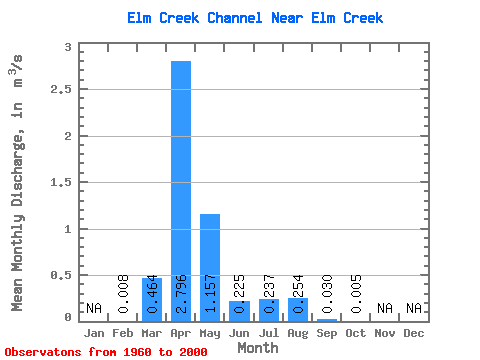
| Statistic | Jan | Feb | Mar | Apr | May | Jun | Jul | Aug | Sep | Oct | Nov | Dec | Annual |
|---|---|---|---|---|---|---|---|---|---|---|---|---|---|
| Mean | 0.01 | 0.46 | 2.80 | 1.16 | 0.23 | 0.24 | 0.25 | 0.03 | 0.01 | ||||
| Standard Deviation | 0.92 | 3.09 | 2.35 | 0.38 | 0.60 | 0.58 | 0.09 | 0.01 | |||||
| Min | 0.01 | 0.00 | 0.01 | 0.00 | 0.00 | 0.00 | 0.00 | 0.00 | 0.00 | ||||
| Max | 0.01 | 3.86 | 10.90 | 9.82 | 1.70 | 2.37 | 1.88 | 0.36 | 0.04 | ||||
| Coefficient of Variation | 1.99 | 1.11 | 2.03 | 1.71 | 2.53 | 2.28 | 3.05 | 2.18 |
 Return to R-Arctic Net Home Page