|
|
|||||||||||||||||
| Point ID: 3039 | Downloads | Plots | Site Data | Code: 05OG005 |
|
|
|||||||||||||||||
| Download | |
|---|---|
| Site Descriptor Information | Site Time Series Data |
| Link to all available data | |
| View: | Time Series | All |
| Units: | m3/s |
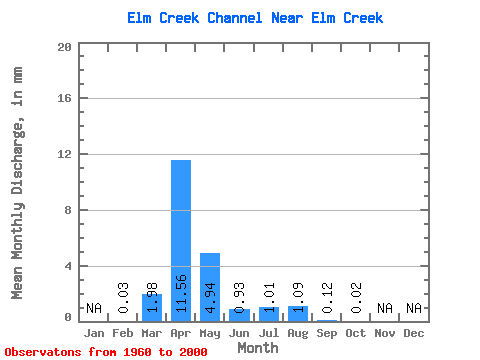
| Statistic | Jan | Feb | Mar | Apr | May | Jun | Jul | Aug | Sep | Oct | Nov | Dec | Annual |
|---|---|---|---|---|---|---|---|---|---|---|---|---|---|
| Mean | 0.03 | 1.98 | 11.56 | 4.94 | 0.93 | 1.01 | 1.08 | 0.12 | 0.02 | ||||
| Standard Deviation | 3.95 | 12.79 | 10.04 | 1.59 | 2.56 | 2.48 | 0.38 | 0.05 | |||||
| Min | 0.03 | 0.00 | 0.02 | 0.00 | 0.00 | 0.00 | 0.00 | 0.00 | 0.00 | ||||
| Max | 0.03 | 16.49 | 45.06 | 41.94 | 7.03 | 10.12 | 8.03 | 1.47 | 0.15 | ||||
| Coefficient of Variation | 1.99 | 1.11 | 2.03 | 1.71 | 2.53 | 2.28 | 3.05 | 2.18 |
 Return to R-Arctic Net Home Page