|
|
|||||||||||||||||
| Point ID: 3027 | Downloads | Plots | Site Data | Code: 05OF015 |
|
|
|||||||||||||||||
| Download | |
|---|---|
| Site Descriptor Information | Site Time Series Data |
| Link to all available data | |
| View: | Time Series | All |
| Units: | mm |
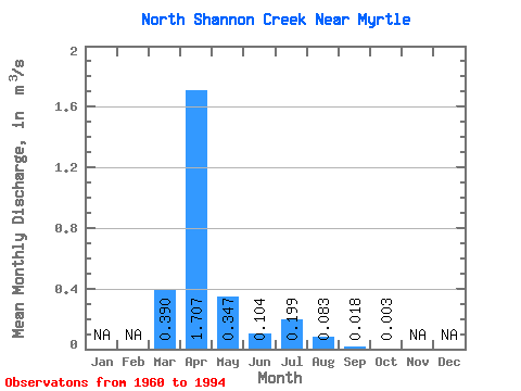
| Statistic | Jan | Feb | Mar | Apr | May | Jun | Jul | Aug | Sep | Oct | Nov | Dec | Annual |
|---|---|---|---|---|---|---|---|---|---|---|---|---|---|
| Mean | 0.39 | 1.71 | 0.35 | 0.10 | 0.20 | 0.08 | 0.02 | 0.00 | |||||
| Standard Deviation | 0.76 | 2.30 | 0.93 | 0.24 | 0.63 | 0.30 | 0.06 | 0.01 | |||||
| Min | 0.00 | 0.00 | 0.00 | 0.00 | 0.00 | 0.00 | 0.00 | 0.00 | |||||
| Max | 3.29 | 8.17 | 4.38 | 1.12 | 2.67 | 1.29 | 0.25 | 0.08 | |||||
| Coefficient of Variation | 1.95 | 1.35 | 2.67 | 2.34 | 3.18 | 3.59 | 3.16 | 4.61 |
 Return to R-Arctic Net Home Page