|
|
|||||||||||||||||
| Point ID: 3027 | Downloads | Plots | Site Data | Code: 05OF015 |
|
|
|||||||||||||||||
| Download | |
|---|---|
| Site Descriptor Information | Site Time Series Data |
| Link to all available data | |
| View: | Time Series | All |
| Units: | m3/s |
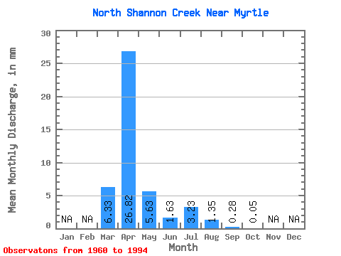
| Statistic | Jan | Feb | Mar | Apr | May | Jun | Jul | Aug | Sep | Oct | Nov | Dec | Annual |
|---|---|---|---|---|---|---|---|---|---|---|---|---|---|
| Mean | 6.33 | 26.81 | 5.64 | 1.63 | 3.23 | 1.34 | 0.29 | 0.05 | |||||
| Standard Deviation | 12.32 | 36.20 | 15.07 | 3.82 | 10.27 | 4.81 | 0.92 | 0.23 | |||||
| Min | 0.00 | 0.03 | 0.00 | 0.00 | 0.00 | 0.00 | 0.00 | 0.00 | |||||
| Max | 53.40 | 128.34 | 71.09 | 17.59 | 43.34 | 20.94 | 3.97 | 1.33 | |||||
| Coefficient of Variation | 1.95 | 1.35 | 2.67 | 2.34 | 3.18 | 3.59 | 3.16 | 4.61 |
 Return to R-Arctic Net Home Page