|
|
|||||||||||||||||
| Point ID: 3018 | Downloads | Plots | Site Data | Code: 05OF003 |
|
|
|||||||||||||||||
| Download | |
|---|---|
| Site Descriptor Information | Site Time Series Data |
| Link to all available data | |
| View: | Time Series | All |
| Units: | mm |
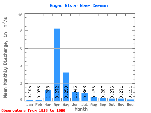
| Statistic | Jan | Feb | Mar | Apr | May | Jun | Jul | Aug | Sep | Oct | Nov | Dec | Annual |
|---|---|---|---|---|---|---|---|---|---|---|---|---|---|
| Mean | 0.10 | 0.10 | 1.28 | 8.27 | 3.26 | 1.04 | 0.86 | 0.50 | 0.29 | 0.28 | 0.27 | 0.15 | 1.41 |
| Standard Deviation | 0.09 | 0.07 | 1.98 | 6.43 | 4.56 | 1.07 | 1.43 | 1.07 | 0.48 | 0.31 | 0.34 | 0.14 | 1.07 |
| Min | 0.00 | 0.00 | 0.00 | 0.07 | 0.24 | 0.02 | 0.01 | 0.00 | 0.00 | 0.00 | 0.00 | 0.00 | 0.12 |
| Max | 0.33 | 0.32 | 8.26 | 26.70 | 23.10 | 5.38 | 7.94 | 5.02 | 2.06 | 1.19 | 1.60 | 0.55 | 3.93 |
| Coefficient of Variation | 0.89 | 0.78 | 1.54 | 0.78 | 1.40 | 1.03 | 1.66 | 2.17 | 1.69 | 1.13 | 1.27 | 0.93 | 0.76 |
 Return to R-Arctic Net Home Page