|
|
|||||||||||||||||
| Point ID: 3018 | Downloads | Plots | Site Data | Code: 05OF003 |
|
|
|||||||||||||||||
| Download | |
|---|---|
| Site Descriptor Information | Site Time Series Data |
| Link to all available data | |
| View: | Time Series | All |
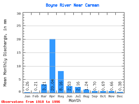
| Units: | m3/s |
| Statistic | Jan | Feb | Mar | Apr | May | Jun | Jul | Aug | Sep | Oct | Nov | Dec | Annual |
|---|---|---|---|---|---|---|---|---|---|---|---|---|---|
| Mean | 0.26 | 0.22 | 3.21 | 20.04 | 8.16 | 2.53 | 2.16 | 1.24 | 0.70 | 0.69 | 0.66 | 0.38 | 41.49 |
| Standard Deviation | 0.23 | 0.17 | 4.96 | 15.58 | 11.41 | 2.60 | 3.58 | 2.69 | 1.18 | 0.78 | 0.84 | 0.35 | 31.65 |
| Min | 0.00 | 0.00 | 0.00 | 0.17 | 0.60 | 0.05 | 0.03 | 0.00 | 0.00 | 0.00 | 0.00 | 0.00 | 3.66 |
| Max | 0.83 | 0.72 | 20.67 | 64.68 | 57.81 | 13.03 | 19.87 | 12.56 | 4.99 | 2.98 | 3.88 | 1.37 | 116.02 |
| Coefficient of Variation | 0.89 | 0.78 | 1.54 | 0.78 | 1.40 | 1.03 | 1.66 | 2.17 | 1.69 | 1.13 | 1.27 | 0.93 | 0.76 |
 Return to R-Arctic Net Home Page