|
|
|||||||||||||||||
| Point ID: 3008 | Downloads | Plots | Site Data | Code: 05OE005 |
|
|
|||||||||||||||||
| Download | |
|---|---|
| Site Descriptor Information | Site Time Series Data |
| Link to all available data | |
| View: | Time Series | All |
| Units: | mm |
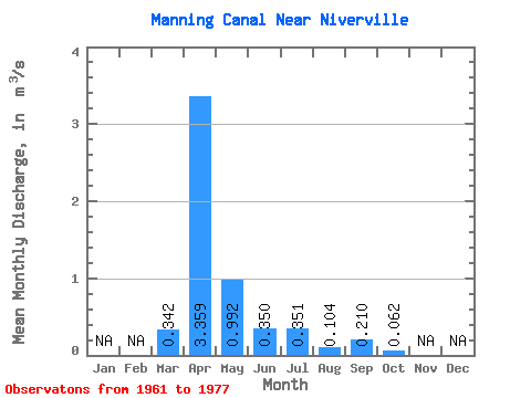
| Statistic | Jan | Feb | Mar | Apr | May | Jun | Jul | Aug | Sep | Oct | Nov | Dec | Annual |
|---|---|---|---|---|---|---|---|---|---|---|---|---|---|
| Mean | 0.34 | 3.36 | 0.99 | 0.35 | 0.35 | 0.10 | 0.21 | 0.06 | |||||
| Standard Deviation | 0.67 | 3.79 | 1.52 | 0.41 | 0.86 | 0.18 | 0.44 | 0.10 | |||||
| Min | 0.00 | 0.09 | 0.01 | 0.01 | 0.00 | 0.00 | 0.00 | 0.00 | |||||
| Max | 2.40 | 11.90 | 5.51 | 1.46 | 3.51 | 0.64 | 1.67 | 0.43 | |||||
| Coefficient of Variation | 1.96 | 1.13 | 1.53 | 1.19 | 2.46 | 1.72 | 2.10 | 1.64 |
 Return to R-Arctic Net Home Page