|
|
|||||||||||||||||
| Point ID: 3008 | Downloads | Plots | Site Data | Code: 05OE005 |
|
|
|||||||||||||||||
| Download | |
|---|---|
| Site Descriptor Information | Site Time Series Data |
| Link to all available data | |
| View: | Time Series | All |
| Units: | m3/s |
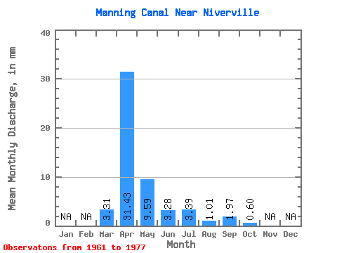
| Statistic | Jan | Feb | Mar | Apr | May | Jun | Jul | Aug | Sep | Oct | Nov | Dec | Annual |
|---|---|---|---|---|---|---|---|---|---|---|---|---|---|
| Mean | 3.30 | 31.43 | 9.59 | 3.28 | 3.39 | 1.00 | 1.97 | 0.60 | |||||
| Standard Deviation | 6.49 | 35.51 | 14.66 | 3.89 | 8.33 | 1.73 | 4.14 | 0.99 | |||||
| Min | 0.00 | 0.86 | 0.14 | 0.12 | 0.00 | 0.00 | 0.00 | 0.00 | |||||
| Max | 23.20 | 111.35 | 53.27 | 13.66 | 33.93 | 6.19 | 15.63 | 4.18 | |||||
| Coefficient of Variation | 1.96 | 1.13 | 1.53 | 1.19 | 2.46 | 1.72 | 2.10 | 1.64 |
 Return to R-Arctic Net Home Page