|
|
|||||||||||||||||
| Point ID: 3005 | Downloads | Plots | Site Data | Code: 05OE001 |
|
|
|||||||||||||||||
| Download | |
|---|---|
| Site Descriptor Information | Site Time Series Data |
| Link to all available data | |
| View: | Time Series | All |
| Units: | mm |
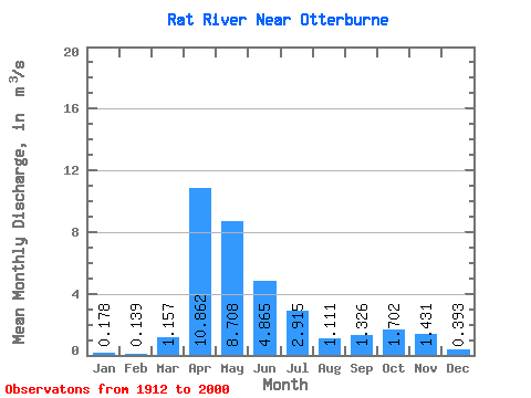
| Statistic | Jan | Feb | Mar | Apr | May | Jun | Jul | Aug | Sep | Oct | Nov | Dec | Annual |
|---|---|---|---|---|---|---|---|---|---|---|---|---|---|
| Mean | 0.18 | 0.14 | 1.16 | 10.86 | 8.71 | 4.87 | 2.92 | 1.11 | 1.33 | 1.70 | 1.43 | 0.39 | 2.63 |
| Standard Deviation | 0.18 | 0.15 | 2.12 | 10.21 | 10.68 | 5.94 | 3.80 | 1.80 | 2.80 | 2.55 | 1.98 | 0.35 | 2.01 |
| Min | 0.00 | 0.00 | 0.00 | 0.81 | 0.54 | 0.08 | 0.00 | 0.00 | 0.00 | 0.00 | 0.01 | 0.00 | 0.26 |
| Max | 0.78 | 0.78 | 11.20 | 49.90 | 63.60 | 41.10 | 19.00 | 10.10 | 18.30 | 13.60 | 11.10 | 1.49 | 9.88 |
| Coefficient of Variation | 1.00 | 1.09 | 1.83 | 0.94 | 1.23 | 1.22 | 1.30 | 1.62 | 2.11 | 1.50 | 1.38 | 0.88 | 0.76 |
 Return to R-Arctic Net Home Page