|
|
|||||||||||||||||
| Point ID: 3005 | Downloads | Plots | Site Data | Code: 05OE001 |
|
|
|||||||||||||||||
| Download | |
|---|---|
| Site Descriptor Information | Site Time Series Data |
| Link to all available data | |
| View: | Time Series | All |
| Units: | m3/s |
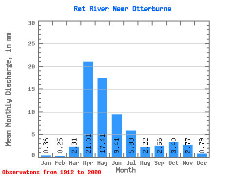
| Statistic | Jan | Feb | Mar | Apr | May | Jun | Jul | Aug | Sep | Oct | Nov | Dec | Annual |
|---|---|---|---|---|---|---|---|---|---|---|---|---|---|
| Mean | 0.35 | 0.25 | 2.31 | 21.01 | 17.40 | 9.41 | 5.83 | 2.22 | 2.56 | 3.40 | 2.77 | 0.79 | 62.01 |
| Standard Deviation | 0.36 | 0.28 | 4.24 | 19.74 | 21.35 | 11.48 | 7.59 | 3.60 | 5.42 | 5.09 | 3.83 | 0.69 | 47.39 |
| Min | 0.00 | 0.00 | 0.00 | 1.57 | 1.08 | 0.15 | 0.00 | 0.00 | 0.00 | 0.00 | 0.01 | 0.00 | 6.16 |
| Max | 1.57 | 1.42 | 22.38 | 96.52 | 127.11 | 79.50 | 37.97 | 20.18 | 35.40 | 27.18 | 21.47 | 2.98 | 232.81 |
| Coefficient of Variation | 1.00 | 1.09 | 1.83 | 0.94 | 1.23 | 1.22 | 1.30 | 1.62 | 2.11 | 1.50 | 1.38 | 0.88 | 0.76 |
 Return to R-Arctic Net Home Page