|
|
|||||||||||||||||
| Point ID: 3 | Downloads | Plots | Site Data | Code: 05AA003 |
|
|
|||||||||||||||||
| Download | |
|---|---|
| Site Descriptor Information | Site Time Series Data |
| Link to all available data | |
| View: | Time Series | All |
| Units: | mm |
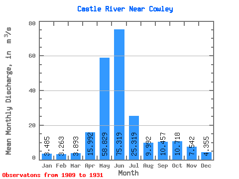
| Statistic | Jan | Feb | Mar | Apr | May | Jun | Jul | Aug | Sep | Oct | Nov | Dec | Annual |
|---|---|---|---|---|---|---|---|---|---|---|---|---|---|
| Mean | 3.48 | 3.26 | 3.89 | 15.99 | 58.83 | 75.32 | 25.32 | 9.99 | 10.46 | 10.72 | 7.54 | 4.36 | 19.32 |
| Standard Deviation | 1.45 | 1.63 | 1.99 | 8.10 | 15.03 | 37.87 | 13.23 | 4.86 | 11.39 | 7.99 | 5.53 | 1.75 | 5.58 |
| Min | 1.75 | 2.02 | 1.86 | 3.60 | 21.90 | 19.90 | 9.79 | 4.55 | 2.97 | 3.58 | 2.89 | 2.18 | 11.37 |
| Max | 7.81 | 9.06 | 9.24 | 31.60 | 96.40 | 187.00 | 57.80 | 21.50 | 54.10 | 27.10 | 24.60 | 8.41 | 31.82 |
| Coefficient of Variation | 0.42 | 0.50 | 0.51 | 0.51 | 0.26 | 0.50 | 0.52 | 0.49 | 1.09 | 0.74 | 0.73 | 0.40 | 0.29 |
 Return to R-Arctic Net Home Page