|
|
|||||||||||||||||
| Point ID: 3 | Downloads | Plots | Site Data | Code: 05AA003 |
|
|
|||||||||||||||||
| Download | |
|---|---|
| Site Descriptor Information | Site Time Series Data |
| Link to all available data | |
| View: | Time Series | All |
| Units: | m3/s |
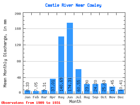
| Statistic | Jan | Feb | Mar | Apr | May | Jun | Jul | Aug | Sep | Oct | Nov | Dec | Annual |
|---|---|---|---|---|---|---|---|---|---|---|---|---|---|
| Mean | 8.33 | 7.11 | 9.31 | 37.01 | 140.66 | 174.31 | 60.54 | 23.89 | 24.20 | 25.63 | 17.45 | 10.41 | 544.48 |
| Standard Deviation | 3.46 | 3.54 | 4.76 | 18.75 | 35.94 | 87.65 | 31.63 | 11.63 | 26.37 | 19.10 | 12.81 | 4.18 | 157.17 |
| Min | 4.18 | 4.40 | 4.45 | 8.33 | 52.36 | 46.05 | 23.41 | 10.88 | 6.87 | 8.56 | 6.69 | 5.21 | 320.46 |
| Max | 18.67 | 19.74 | 22.09 | 73.13 | 230.50 | 432.77 | 138.20 | 51.41 | 125.20 | 64.80 | 56.93 | 20.11 | 896.76 |
| Coefficient of Variation | 0.42 | 0.50 | 0.51 | 0.51 | 0.26 | 0.50 | 0.52 | 0.49 | 1.09 | 0.74 | 0.73 | 0.40 | 0.29 |
 Return to R-Arctic Net Home Page