|
|
|||||||||||||||||
| Point ID: 2998 | Downloads | Plots | Site Data | Code: 05OD027 |
|
|
|||||||||||||||||
| Download | |
|---|---|
| Site Descriptor Information | Site Time Series Data |
| Link to all available data | |
| View: | Time Series | All |
| Units: | mm |
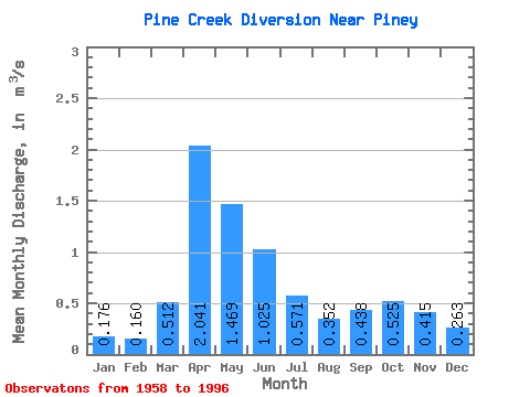
| Statistic | Jan | Feb | Mar | Apr | May | Jun | Jul | Aug | Sep | Oct | Nov | Dec | Annual |
|---|---|---|---|---|---|---|---|---|---|---|---|---|---|
| Mean | 0.18 | 0.16 | 0.51 | 2.04 | 1.47 | 1.02 | 0.57 | 0.35 | 0.44 | 0.53 | 0.41 | 0.26 | 0.66 |
| Standard Deviation | 0.07 | 0.07 | 0.43 | 1.03 | 1.01 | 0.77 | 0.59 | 0.42 | 0.36 | 0.37 | 0.24 | 0.15 | 0.21 |
| Min | 0.01 | 0.01 | 0.07 | 0.45 | 0.30 | 0.15 | 0.11 | 0.09 | 0.09 | 0.14 | 0.13 | 0.11 | 0.27 |
| Max | 0.37 | 0.31 | 1.93 | 4.66 | 4.38 | 3.18 | 2.38 | 2.20 | 1.45 | 1.54 | 1.51 | 0.79 | 1.16 |
| Coefficient of Variation | 0.42 | 0.41 | 0.84 | 0.50 | 0.69 | 0.75 | 1.04 | 1.20 | 0.82 | 0.70 | 0.57 | 0.58 | 0.32 |
 Return to R-Arctic Net Home Page