|
|
|||||||||||||||||
| Point ID: 2998 | Downloads | Plots | Site Data | Code: 05OD027 |
|
|
|||||||||||||||||
| Download | |
|---|---|
| Site Descriptor Information | Site Time Series Data |
| Link to all available data | |
| View: | Time Series | All |
| Units: | m3/s |
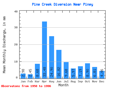
| Statistic | Jan | Feb | Mar | Apr | May | Jun | Jul | Aug | Sep | Oct | Nov | Dec | Annual |
|---|---|---|---|---|---|---|---|---|---|---|---|---|---|
| Mean | 2.99 | 2.47 | 8.68 | 33.48 | 24.90 | 16.82 | 9.68 | 5.96 | 7.18 | 8.91 | 6.81 | 4.46 | 132.29 |
| Standard Deviation | 1.27 | 1.00 | 7.30 | 16.86 | 17.11 | 12.55 | 10.07 | 7.13 | 5.89 | 6.22 | 3.89 | 2.59 | 42.40 |
| Min | 0.22 | 0.22 | 1.12 | 7.32 | 5.02 | 2.41 | 1.92 | 1.51 | 1.53 | 2.37 | 2.07 | 1.83 | 54.61 |
| Max | 6.32 | 4.83 | 32.71 | 76.45 | 74.24 | 52.17 | 40.34 | 37.29 | 23.79 | 26.10 | 24.77 | 13.44 | 231.71 |
| Coefficient of Variation | 0.42 | 0.41 | 0.84 | 0.50 | 0.69 | 0.75 | 1.04 | 1.20 | 0.82 | 0.70 | 0.57 | 0.58 | 0.32 |
 Return to R-Arctic Net Home Page