|
|
|||||||||||||||||
| Point ID: 2985 | Downloads | Plots | Site Data | Code: 05OC016 |
|
|
|||||||||||||||||
| Download | |
|---|---|
| Site Descriptor Information | Site Time Series Data |
| Link to all available data | |
| View: | Time Series | All |
| Units: | mm |
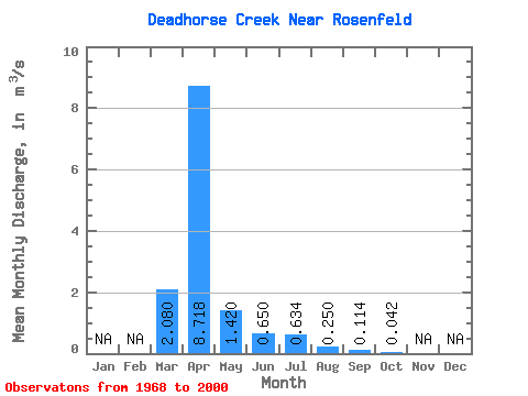
| Statistic | Jan | Feb | Mar | Apr | May | Jun | Jul | Aug | Sep | Oct | Nov | Dec | Annual |
|---|---|---|---|---|---|---|---|---|---|---|---|---|---|
| Mean | 2.08 | 8.72 | 1.42 | 0.65 | 0.63 | 0.25 | 0.11 | 0.04 | |||||
| Standard Deviation | 4.15 | 12.91 | 3.11 | 1.11 | 1.64 | 0.65 | 0.35 | 0.07 | |||||
| Min | 0.00 | 0.01 | 0.00 | 0.02 | 0.00 | 0.00 | 0.00 | 0.00 | |||||
| Max | 17.00 | 47.80 | 16.40 | 4.62 | 7.87 | 2.62 | 1.77 | 0.22 | |||||
| Coefficient of Variation | 2.00 | 1.48 | 2.19 | 1.70 | 2.59 | 2.58 | 3.07 | 1.63 |
 Return to R-Arctic Net Home Page