|
|
|||||||||||||||||
| Point ID: 2985 | Downloads | Plots | Site Data | Code: 05OC016 |
|
|
|||||||||||||||||
| Download | |
|---|---|
| Site Descriptor Information | Site Time Series Data |
| Link to all available data | |
| View: | Time Series | All |
| Units: | m3/s |
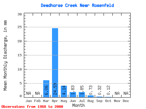
| Statistic | Jan | Feb | Mar | Apr | May | Jun | Jul | Aug | Sep | Oct | Nov | Dec | Annual |
|---|---|---|---|---|---|---|---|---|---|---|---|---|---|
| Mean | 6.06 | 24.59 | 4.14 | 1.83 | 1.85 | 0.73 | 0.32 | 0.12 | |||||
| Standard Deviation | 12.11 | 36.42 | 9.06 | 3.12 | 4.79 | 1.89 | 0.98 | 0.20 | |||||
| Min | 0.00 | 0.02 | 0.01 | 0.06 | 0.00 | 0.00 | 0.00 | 0.00 | |||||
| Max | 49.54 | 134.82 | 47.79 | 13.03 | 22.93 | 7.63 | 4.99 | 0.65 | |||||
| Coefficient of Variation | 2.00 | 1.48 | 2.19 | 1.70 | 2.59 | 2.58 | 3.07 | 1.63 |
 Return to R-Arctic Net Home Page