|
|
|||||||||||||||||
| Point ID: 2974 | Downloads | Plots | Site Data | Code: 05OB019 |
|
|
|||||||||||||||||
| Download | |
|---|---|
| Site Descriptor Information | Site Time Series Data |
| Link to all available data | |
| View: | Time Series | All |
| Units: | mm |
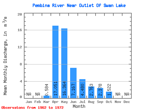
| Statistic | Jan | Feb | Mar | Apr | May | Jun | Jul | Aug | Sep | Oct | Nov | Dec | Annual |
|---|---|---|---|---|---|---|---|---|---|---|---|---|---|
| Mean | 0.58 | 17.05 | 16.36 | 7.17 | 4.48 | 2.76 | 2.38 | 1.52 | |||||
| Standard Deviation | 1.31 | 23.42 | 13.71 | 6.54 | 4.07 | 2.03 | 2.99 | 2.32 | |||||
| Min | 0.00 | 1.52 | 0.65 | 0.43 | 0.49 | 0.08 | 0.04 | 0.02 | |||||
| Max | 4.34 | 81.70 | 42.70 | 24.90 | 14.70 | 6.89 | 10.50 | 7.87 | |||||
| Coefficient of Variation | 2.24 | 1.37 | 0.84 | 0.91 | 0.91 | 0.74 | 1.26 | 1.52 |
 Return to R-Arctic Net Home Page