|
|
|||||||||||||||||
| Point ID: 2974 | Downloads | Plots | Site Data | Code: 05OB019 |
|
|
|||||||||||||||||
| Download | |
|---|---|
| Site Descriptor Information | Site Time Series Data |
| Link to all available data | |
| View: | Time Series | All |
| Units: | m3/s |
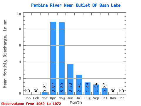
| Statistic | Jan | Feb | Mar | Apr | May | Jun | Jul | Aug | Sep | Oct | Nov | Dec | Annual |
|---|---|---|---|---|---|---|---|---|---|---|---|---|---|
| Mean | 0.31 | 8.88 | 8.80 | 3.73 | 2.41 | 1.49 | 1.24 | 0.82 | |||||
| Standard Deviation | 0.70 | 12.19 | 7.37 | 3.40 | 2.19 | 1.09 | 1.56 | 1.25 | |||||
| Min | 0.00 | 0.79 | 0.35 | 0.22 | 0.27 | 0.04 | 0.02 | 0.01 | |||||
| Max | 2.33 | 42.52 | 22.96 | 12.96 | 7.91 | 3.71 | 5.46 | 4.23 | |||||
| Coefficient of Variation | 2.24 | 1.37 | 0.84 | 0.91 | 0.91 | 0.74 | 1.26 | 1.52 |
 Return to R-Arctic Net Home Page