|
|
|||||||||||||||||
| Point ID: 297 | Downloads | Plots | Site Data | Code: 05BJ009 |
|
|
|||||||||||||||||
| Download | |
|---|---|
| Site Descriptor Information | Site Time Series Data |
| Link to all available data | |
| View: | Time Series | All |
| Units: | mm |
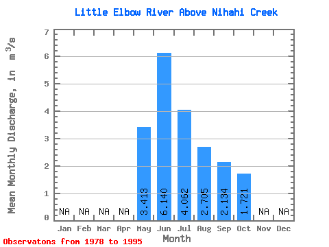
| Statistic | Jan | Feb | Mar | Apr | May | Jun | Jul | Aug | Sep | Oct | Nov | Dec | Annual |
|---|---|---|---|---|---|---|---|---|---|---|---|---|---|
| Mean | 3.41 | 6.14 | 4.06 | 2.71 | 2.13 | 1.72 | |||||||
| Standard Deviation | 1.30 | 1.97 | 1.76 | 0.95 | 0.68 | 0.38 | |||||||
| Min | 1.52 | 3.17 | 2.13 | 1.64 | 1.36 | 1.18 | |||||||
| Max | 6.39 | 9.86 | 7.65 | 5.77 | 4.01 | 2.65 | |||||||
| Coefficient of Variation | 0.38 | 0.32 | 0.43 | 0.35 | 0.32 | 0.22 |
 Return to R-Arctic Net Home Page