|
|
|||||||||||||||||
| Point ID: 297 | Downloads | Plots | Site Data | Code: 05BJ009 |
|
|
|||||||||||||||||
| Download | |
|---|---|
| Site Descriptor Information | Site Time Series Data |
| Link to all available data | |
| View: | Time Series | All |
| Units: | m3/s |
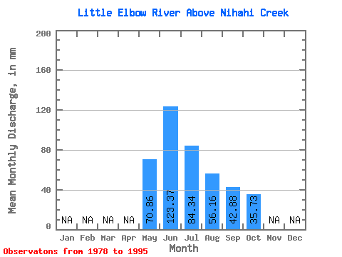
| Statistic | Jan | Feb | Mar | Apr | May | Jun | Jul | Aug | Sep | Oct | Nov | Dec | Annual |
|---|---|---|---|---|---|---|---|---|---|---|---|---|---|
| Mean | 70.85 | 123.37 | 84.32 | 56.15 | 42.88 | 35.73 | |||||||
| Standard Deviation | 26.97 | 39.67 | 36.62 | 19.71 | 13.61 | 7.86 | |||||||
| Min | 31.55 | 63.70 | 44.22 | 34.05 | 27.33 | 24.50 | |||||||
| Max | 132.65 | 198.12 | 158.81 | 119.78 | 80.57 | 55.01 | |||||||
| Coefficient of Variation | 0.38 | 0.32 | 0.43 | 0.35 | 0.32 | 0.22 |
 Return to R-Arctic Net Home Page