|
|
|||||||||||||||||
| Point ID: 2969 | Downloads | Plots | Site Data | Code: 05OB007 |
|
|
|||||||||||||||||
| Download | |
|---|---|
| Site Descriptor Information | Site Time Series Data |
| Link to all available data | |
| View: | Time Series | All |
| Units: | mm |
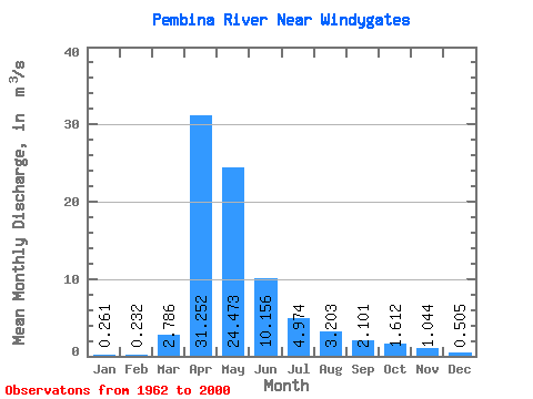
| Statistic | Jan | Feb | Mar | Apr | May | Jun | Jul | Aug | Sep | Oct | Nov | Dec | Annual |
|---|---|---|---|---|---|---|---|---|---|---|---|---|---|
| Mean | 0.26 | 0.23 | 2.79 | 31.25 | 24.47 | 10.16 | 4.97 | 3.20 | 2.10 | 1.61 | 1.04 | 0.51 | 6.88 |
| Standard Deviation | 0.41 | 0.38 | 4.98 | 34.92 | 28.18 | 11.77 | 6.27 | 4.32 | 2.88 | 2.29 | 1.91 | 0.93 | 6.63 |
| Min | 0.00 | 0.00 | 0.00 | 0.60 | 0.77 | 0.11 | 0.00 | 0.00 | 0.00 | 0.00 | 0.00 | 0.00 | 0.23 |
| Max | 2.34 | 1.84 | 26.90 | 121.00 | 102.00 | 49.60 | 31.90 | 20.40 | 15.40 | 9.71 | 11.10 | 5.53 | 24.72 |
| Coefficient of Variation | 1.59 | 1.63 | 1.79 | 1.12 | 1.15 | 1.16 | 1.26 | 1.35 | 1.37 | 1.42 | 1.83 | 1.83 | 0.96 |
 Return to R-Arctic Net Home Page