|
|
|||||||||||||||||
| Point ID: 2969 | Downloads | Plots | Site Data | Code: 05OB007 |
|
|
|||||||||||||||||
| Download | |
|---|---|
| Site Descriptor Information | Site Time Series Data |
| Link to all available data | |
| View: | Time Series | All |
| Units: | m3/s |
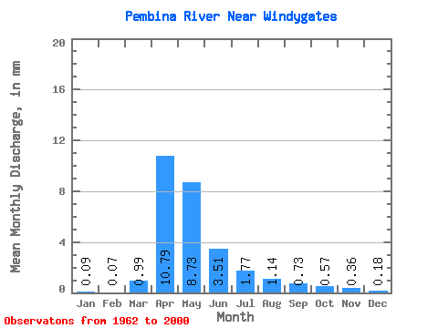
| Statistic | Jan | Feb | Mar | Apr | May | Jun | Jul | Aug | Sep | Oct | Nov | Dec | Annual |
|---|---|---|---|---|---|---|---|---|---|---|---|---|---|
| Mean | 0.09 | 0.07 | 0.99 | 10.79 | 8.73 | 3.50 | 1.77 | 1.14 | 0.72 | 0.57 | 0.36 | 0.18 | 28.93 |
| Standard Deviation | 0.15 | 0.12 | 1.77 | 12.05 | 10.05 | 4.06 | 2.24 | 1.54 | 0.99 | 0.81 | 0.66 | 0.33 | 27.88 |
| Min | 0.00 | 0.00 | 0.00 | 0.21 | 0.27 | 0.04 | 0.00 | 0.00 | 0.00 | 0.00 | 0.00 | 0.00 | 0.97 |
| Max | 0.83 | 0.60 | 9.59 | 41.76 | 36.37 | 17.12 | 11.38 | 7.27 | 5.32 | 3.46 | 3.83 | 1.97 | 103.87 |
| Coefficient of Variation | 1.59 | 1.63 | 1.79 | 1.12 | 1.15 | 1.16 | 1.26 | 1.35 | 1.37 | 1.42 | 1.83 | 1.83 | 0.96 |
 Return to R-Arctic Net Home Page