|
|
|||||||||||||||||
| Point ID: 2960 | Downloads | Plots | Site Data | Code: 05OA009 |
|
|
|||||||||||||||||
| Download | |
|---|---|
| Site Descriptor Information | Site Time Series Data |
| Link to all available data | |
| View: | Time Series | All |
| Units: | mm |
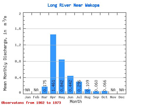
| Statistic | Jan | Feb | Mar | Apr | May | Jun | Jul | Aug | Sep | Oct | Nov | Dec | Annual |
|---|---|---|---|---|---|---|---|---|---|---|---|---|---|
| Mean | 0.17 | 1.46 | 0.84 | 0.44 | 0.30 | 0.11 | 0.06 | 0.07 | |||||
| Standard Deviation | 0.29 | 1.63 | 0.80 | 0.35 | 0.35 | 0.14 | 0.11 | 0.10 | |||||
| Min | 0.00 | 0.05 | 0.04 | 0.01 | 0.00 | 0.00 | 0.00 | 0.00 | |||||
| Max | 0.86 | 5.82 | 2.40 | 1.07 | 1.00 | 0.43 | 0.31 | 0.33 | |||||
| Coefficient of Variation | 1.69 | 1.11 | 0.95 | 0.78 | 1.20 | 1.33 | 1.83 | 1.58 |
 Return to R-Arctic Net Home Page