|
|
|||||||||||||||||
| Point ID: 2960 | Downloads | Plots | Site Data | Code: 05OA009 |
|
|
|||||||||||||||||
| Download | |
|---|---|
| Site Descriptor Information | Site Time Series Data |
| Link to all available data | |
| View: | Time Series | All |
| Units: | m3/s |
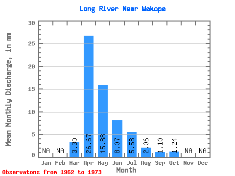
| Statistic | Jan | Feb | Mar | Apr | May | Jun | Jul | Aug | Sep | Oct | Nov | Dec | Annual |
|---|---|---|---|---|---|---|---|---|---|---|---|---|---|
| Mean | 3.29 | 26.66 | 15.88 | 8.07 | 5.58 | 2.06 | 1.10 | 1.25 | |||||
| Standard Deviation | 5.57 | 29.70 | 15.08 | 6.32 | 6.67 | 2.73 | 2.01 | 1.96 | |||||
| Min | 0.00 | 0.84 | 0.85 | 0.16 | 0.00 | 0.00 | 0.00 | 0.00 | |||||
| Max | 16.24 | 106.23 | 45.26 | 19.53 | 18.86 | 8.07 | 5.71 | 6.21 | |||||
| Coefficient of Variation | 1.69 | 1.11 | 0.95 | 0.78 | 1.20 | 1.33 | 1.83 | 1.58 |
 Return to R-Arctic Net Home Page