|
|
|||||||||||||||||
| Point ID: 296 | Downloads | Plots | Site Data | Code: 05BJ006 |
|
|
|||||||||||||||||
| Download | |
|---|---|
| Site Descriptor Information | Site Time Series Data |
| Link to all available data | |
| View: | Time Series | All |
| Units: | mm |
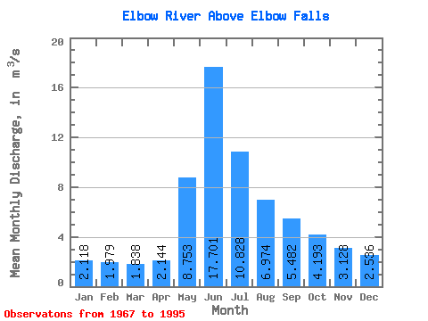
| Statistic | Jan | Feb | Mar | Apr | May | Jun | Jul | Aug | Sep | Oct | Nov | Dec | Annual |
|---|---|---|---|---|---|---|---|---|---|---|---|---|---|
| Mean | 2.12 | 1.98 | 1.84 | 2.14 | 8.75 | 17.70 | 10.83 | 6.97 | 5.48 | 4.19 | 3.13 | 2.54 | 6.00 |
| Standard Deviation | 0.29 | 0.22 | 0.24 | 0.26 | 3.52 | 7.01 | 4.59 | 2.09 | 1.79 | 0.92 | 0.38 | 0.24 | 0.87 |
| Min | 1.59 | 1.68 | 1.45 | 1.63 | 3.21 | 7.03 | 4.05 | 3.89 | 2.95 | 2.69 | 2.59 | 2.19 | 5.05 |
| Max | 2.70 | 2.31 | 2.43 | 2.84 | 18.50 | 32.50 | 21.70 | 13.60 | 10.70 | 6.49 | 3.70 | 2.89 | 7.37 |
| Coefficient of Variation | 0.14 | 0.11 | 0.13 | 0.12 | 0.40 | 0.40 | 0.42 | 0.30 | 0.33 | 0.22 | 0.12 | 0.09 | 0.14 |
 Return to R-Arctic Net Home Page