|
|
|||||||||||||||||
| Point ID: 296 | Downloads | Plots | Site Data | Code: 05BJ006 |
|
|
|||||||||||||||||
| Download | |
|---|---|
| Site Descriptor Information | Site Time Series Data |
| Link to all available data | |
| View: | Time Series | All |
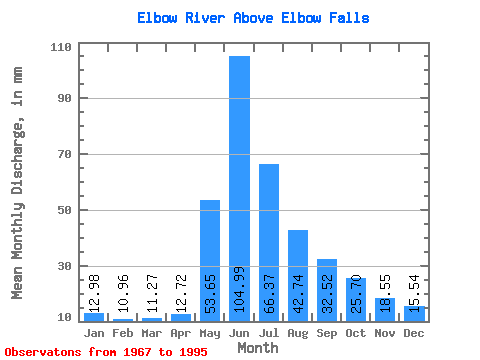
| Units: | m3/s |
| Statistic | Jan | Feb | Mar | Apr | May | Jun | Jul | Aug | Sep | Oct | Nov | Dec | Annual |
|---|---|---|---|---|---|---|---|---|---|---|---|---|---|
| Mean | 12.98 | 11.05 | 11.26 | 12.72 | 53.64 | 104.99 | 66.36 | 42.74 | 32.52 | 25.70 | 18.55 | 15.54 | 433.66 |
| Standard Deviation | 1.78 | 1.25 | 1.46 | 1.55 | 21.60 | 41.60 | 28.16 | 12.82 | 10.61 | 5.66 | 2.25 | 1.45 | 62.79 |
| Min | 9.74 | 9.38 | 8.89 | 9.67 | 19.67 | 41.70 | 24.82 | 23.84 | 17.50 | 16.48 | 15.36 | 13.42 | 364.53 |
| Max | 16.55 | 12.90 | 14.89 | 16.84 | 113.37 | 192.77 | 132.98 | 83.34 | 63.47 | 39.77 | 21.95 | 17.71 | 532.44 |
| Coefficient of Variation | 0.14 | 0.11 | 0.13 | 0.12 | 0.40 | 0.40 | 0.42 | 0.30 | 0.33 | 0.22 | 0.12 | 0.09 | 0.14 |
 Return to R-Arctic Net Home Page