|
|
|||||||||||||||||
| Point ID: 2955 | Downloads | Plots | Site Data | Code: 05OA002 |
|
|
|||||||||||||||||
| Download | |
|---|---|
| Site Descriptor Information | Site Time Series Data |
| Link to all available data | |
| View: | Time Series | All |
| Units: | mm |
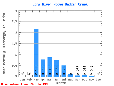
| Statistic | Jan | Feb | Mar | Apr | May | Jun | Jul | Aug | Sep | Oct | Nov | Dec | Annual |
|---|---|---|---|---|---|---|---|---|---|---|---|---|---|
| Mean | 2.13 | 0.78 | 0.88 | 0.75 | 0.51 | 0.11 | 0.06 | 0.09 | 0.05 | ||||
| Standard Deviation | 0.35 | 1.68 | 0.93 | 0.74 | 0.15 | 0.07 | 0.09 | ||||||
| Min | 2.13 | 0.18 | 0.06 | 0.03 | 0.01 | 0.01 | 0.01 | 0.01 | 0.05 | ||||
| Max | 2.13 | 1.15 | 5.80 | 2.60 | 2.14 | 0.42 | 0.23 | 0.26 | 0.05 | ||||
| Coefficient of Variation | 0.45 | 1.92 | 1.24 | 1.46 | 1.33 | 1.28 | 1.05 |
 Return to R-Arctic Net Home Page