|
|
|||||||||||||||||
| Point ID: 2955 | Downloads | Plots | Site Data | Code: 05OA002 |
|
|
|||||||||||||||||
| Download | |
|---|---|
| Site Descriptor Information | Site Time Series Data |
| Link to all available data | |
| View: | Time Series | All |
| Units: | m3/s |
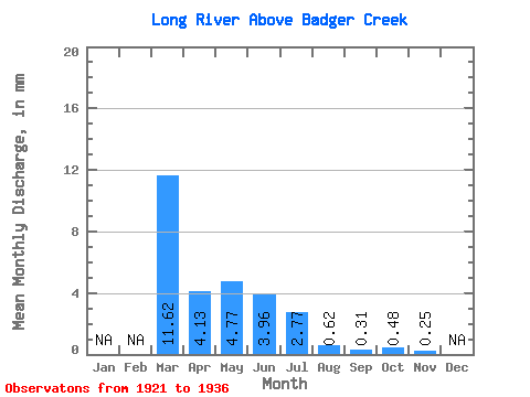
| Statistic | Jan | Feb | Mar | Apr | May | Jun | Jul | Aug | Sep | Oct | Nov | Dec | Annual |
|---|---|---|---|---|---|---|---|---|---|---|---|---|---|
| Mean | 11.62 | 4.13 | 4.77 | 3.96 | 2.77 | 0.62 | 0.31 | 0.48 | 0.25 | ||||
| Standard Deviation | 1.87 | 9.13 | 4.92 | 4.04 | 0.83 | 0.39 | 0.51 | ||||||
| Min | 11.62 | 0.97 | 0.32 | 0.14 | 0.08 | 0.05 | 0.05 | 0.06 | 0.25 | ||||
| Max | 11.62 | 6.07 | 31.63 | 13.72 | 11.67 | 2.27 | 1.19 | 1.41 | 0.25 | ||||
| Coefficient of Variation | 0.45 | 1.92 | 1.24 | 1.46 | 1.33 | 1.28 | 1.05 |
 Return to R-Arctic Net Home Page