|
|
|||||||||||||||||
| Point ID: 2949 | Downloads | Plots | Site Data | Code: 05NG021 |
|
|
|||||||||||||||||
| Download | |
|---|---|
| Site Descriptor Information | Site Time Series Data |
| Link to all available data | |
| View: | Time Series | All |
| Units: | mm |
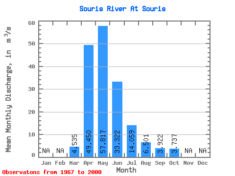
| Statistic | Jan | Feb | Mar | Apr | May | Jun | Jul | Aug | Sep | Oct | Nov | Dec | Annual |
|---|---|---|---|---|---|---|---|---|---|---|---|---|---|
| Mean | 4.54 | 49.45 | 57.82 | 33.32 | 14.06 | 6.50 | 3.92 | 3.74 | |||||
| Standard Deviation | 5.64 | 87.84 | 74.55 | 50.70 | 20.49 | 7.66 | 4.91 | 5.18 | |||||
| Min | 0.08 | 0.33 | 0.08 | 0.06 | 0.36 | 0.14 | 0.43 | 0.30 | |||||
| Max | 17.30 | 483.00 | 278.00 | 189.00 | 80.80 | 37.20 | 26.80 | 27.50 | |||||
| Coefficient of Variation | 1.25 | 1.78 | 1.29 | 1.52 | 1.46 | 1.18 | 1.25 | 1.39 |
 Return to R-Arctic Net Home Page