|
|
|||||||||||||||||
| Point ID: 2949 | Downloads | Plots | Site Data | Code: 05NG021 |
|
|
|||||||||||||||||
| Download | |
|---|---|
| Site Descriptor Information | Site Time Series Data |
| Link to all available data | |
| View: | Time Series | All |
| Units: | m3/s |
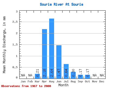
| Statistic | Jan | Feb | Mar | Apr | May | Jun | Jul | Aug | Sep | Oct | Nov | Dec | Annual |
|---|---|---|---|---|---|---|---|---|---|---|---|---|---|
| Mean | 0.21 | 2.18 | 2.64 | 1.47 | 0.64 | 0.30 | 0.17 | 0.17 | |||||
| Standard Deviation | 0.26 | 3.88 | 3.40 | 2.24 | 0.94 | 0.35 | 0.22 | 0.24 | |||||
| Min | 0.00 | 0.01 | 0.00 | 0.00 | 0.02 | 0.01 | 0.02 | 0.01 | |||||
| Max | 0.79 | 21.33 | 12.68 | 8.35 | 3.69 | 1.70 | 1.18 | 1.25 | |||||
| Coefficient of Variation | 1.25 | 1.78 | 1.29 | 1.52 | 1.46 | 1.18 | 1.25 | 1.39 |
 Return to R-Arctic Net Home Page